Forecasting tech’s come a long way, no question, but experienced pros will tell you the atmosphere can’t be fully understood just by staring at a screen. A seasoned Tornado Storm Chaser spends just as much time watching the actual sky as they do studying radar. Cloud movement, shifting winds, small changes in the air, all of it tells you something radar alone can’t.
For anyone joining Storm Chaser Trips, this ends up being one of the most fascinating parts of the whole experience. Turns out reading the sky is a skill built over years of paying attention, not something you learn from an app in an afternoon.
Every Storm Leaves Clues
The atmosphere rarely shifts without giving some kind of warning first. Before a thunderstorm turns severe, the sky usually shows small, easy-to-miss signs that experienced chasers know exactly how to spot.
Clouds might start building vertically, wind can shift direction out of nowhere, and humidity gets noticeably heavier. Most people wouldn’t think twice about any of that, but a trained Tornado Storm Chaser reads it as a sign the atmosphere’s getting primed for something bigger. All of that gets compared against the latest forecasts while they’re out in the field.
Clouds Tell Their Own Story
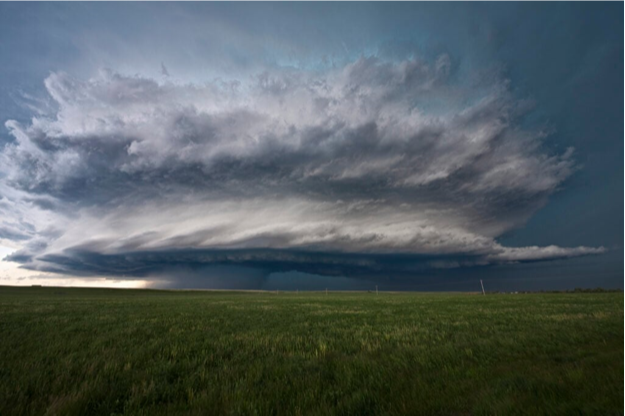
One of the first things chasers actually watch is how clouds are developing. Towering cumulus clouds usually mean warm, moist air rising fast. As those clouds keep building, they can organize into full thunderstorms capable of turning severe.
Instead of fixating on one single cloud, experienced chasers watch how the whole sky’s shifting over time. They’re looking for a growing organization, stronger updrafts, structures that hint at a storm’s maturing. Those visual reads are exactly what help a Tornado Storm Chaser decide if a storm’s worth closer attention, or if conditions just aren’t there yet.
Wind Is Just as Important
Clouds only give you part of the story. Wind direction and speed reveal a lot about how different layers of the atmosphere are interacting. Watching trees sway, grass bend, dust kick up, and even how low clouds are moving, all of that adds useful context. That kind of observation matters even more when the forecast’s uncertain or a storm starts behaving differently than expected.
Looking Beyond Technology
Radar and satellite imagery are still essential tools, sure, but they don’t replace actually looking outside.
Experienced chasers are constantly checking what the tech’s telling them against what they can see with their own eyes. If clouds develop differently than forecast, or wind starts shifting unexpectedly, guides will adjust plans right then and there. That mix of tech and hands-on observation is exactly what makes Storm Chaser Trips feel both educational and genuinely dynamic. Guests get to watch real decisions being made in real time, not just trust a computer model unquestioningly.
Reading the Bigger Picture
Pros don’t lock in on just one storm cell and ignore everything else. They’re reading the whole environment around it.
During a chase, they might be checking:
- Cloud growth across a wide area
- Wind changes near the surface
- Visibility and storm movement
- Areas of increasing instability
- New storm development nearby
Looking at that bigger picture is what gives them a fuller sense of how the whole weather system’s evolving, not just one piece of it.
Experience Makes the Difference
Two people can stand in the same spot, staring at the same sky, and notice completely different things. Years spent out in the field teach a Tornado Storm Chaser how to catch subtle patterns most people would just walk right past. That knowledge is really what tells them whether a storm’s strengthening, fading, or about to change direction, often before it’s obvious to anyone else. That’s honestly a big reason guided tours end up being such a rich learning experience.
Learning During Storm Chaser Trips
A lot of guests show up on Storm Chaser Trips expecting a crash course in radar and forecasting models. What they often discover instead is that simple observation matters just as much. Guides explain why clouds shift shape, how wind shapes storm development, and what visual cues actually matter throughout the day. Those conversations end up giving guests a much deeper appreciation for meteorology and honestly make the whole trip feel way more engaging than just watching storms pass from a distance.
By the end, a lot of travelers say they’re noticing weather patterns they never even registered before.
Nature Is the Best Classroom
Every storm behaves a little differently, which means every chase is a fresh chance to learn something new. Watching clouds evolve across those open Plains teaches patience, careful observation, and a real respect for the atmosphere. Tech’s useful, sure, but it’s careful interpretation that lets experienced guides actually understand what’s happening in the moment. For a professional Tornado Storm Chaser, reading the sky remains one of the most valuable skills in the whole job.
Final Thoughts
Storm chasing runs on a lot more than just forecasts and radar screens. Careful observation of clouds, wind, and shifting conditions still plays a huge role in every successful chase. For anyone joining Storm Chaser Trips, that behind-the-scenes knowledge turns the whole adventure into something genuinely educational. Watching how a Tornado Storm Chaser actually reads the sky shows you that some of the best forecasting tools out there are still experience, patience, and paying close attention to nature itself.